Garmin
tactix 8
tactix 8
SKU:GM-010-03406-14
Couldn't load pickup availability
BUILT FOR THE MISSION
Rise above with tactix 8. It’s the ultimate tactical smartwatch, featuring a stunning AMOLED/solar charged display, titanium bezel, sapphire lens, an internal speaker and mic for voice features and a 40-meter dive rating.
BUILT TO ENDURE
AMOLED
This advanced tactical GPS smartwatch features a bright 1.4-inch AMOLED display, titanium bezel and sapphire lens, and enhanced graphical interface. It’s tested to U.S. military standards for thermal, shock and water resistance.
Sapphire Solar
This advanced tactical GPS smartwatch features a bright 1.4-inch solar charged display, titanium bezel and sapphire lens, and enhanced graphical interface. It’s tested to U.S. military standards for thermal, shock and water resistance.
MISSION-READY
Dedicated tactical features include a jumpmaster activity, waypoint projection, dual-position GPS format, stealth mode, kill switch, compatibility with night vision goggles and rucking activity.
LEAD THE CHARGE
Navigate the outdoors with superior positioning accuracy, thanks to multi-band GPS with SatIQ™ technology plus built-in sensors for the 3-axis compass, gyroscope and barometric altimeter.
APPLIED BALLISTICS
The preloaded Applied Ballistics solver gives you access to aiming solutions for long-range shooting in the field.
RECREATIONAL DIVING
With a 40-meter dive rating, you’re ready to go to greater depths than ever with support for scuba and apnea dive activities.
BUILT-IN FLASHLIGHT
To help guide your way in low-light conditions, a built-in multicolor LED flashlight provides quick access to a bright, steady beam in either green or white light. In NVG mode, white is disabled, and the green flashlight becomes dimmable.
NIGHT VISION CAPABILITY
Whether viewed under NODs or operating in the dark, NVG mode allows for stealthy operation with controls to further dim brightness and black out the display to reduce detectability.
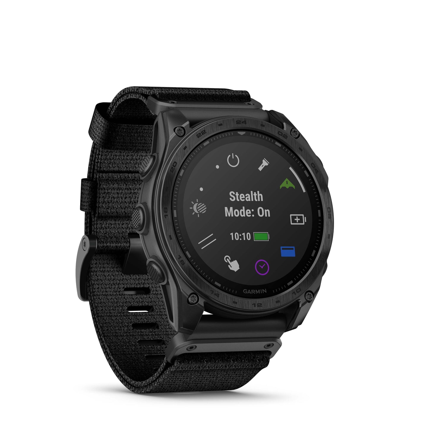
STEALTH MODE
While keeping the watch operational, stealth mode stops storing and sharing your GPS position and disables wireless connectivity and communication.
PROJECTED WAYPOINTS
Set and save remote geo positions to be used later for navigation.
RUCKING ACTIVITY
A dedicated rucking activity profile allows you to input your pack weight.
DIRECT-TO NAVIGATION
Navigate straight to a location or waypoint in the worldwide aeronautical database. Or choose the Nearest function to activate a path to a nearby airport.
WEATHER REPORTS
Access aviation weather, including NEXRAD radar, METARs and TAFs, to see winds, visibility, barometric pressure and more.